Kully Bay Overland Flow Study

Share on Facebook Share on Twitter Share on Linkedin Email this link

Consultation has concluded

As part of our commitment to managing flood and stormwater in our region, we’re working on an overland flow study for the Kully Bay catchment. This Study will explain the ways flooding happens in the Kully Bay catchment, which includes residential and commercial land in Warrawong and Port Kembla. Overland flow is rainfall runoff from homes, driveways and other surfaces.

We’ll be sharing the report with the community during the public exhibition from 26 August to 23 September 2019. Come along to our drop-in community information session where the floodplain engineers working on the Study will be available to answer your questions. There’s no formal presentation as such. Instead, we’ll have the report available for viewing, display stands showing flood mitigation projects, flood modelling maps and a short flood modelling video to help explain how and where it can flood in this catchment. This is a drop-in session, so you can come in at any time.

When: Saturday 7 September 2019, drop in anytime between 10am – 11:30am
Where: Warrawong Community Centre, 7-9 Greene Street, Warrawong

If you’d like to attend and have accessibility or mobility requirements, or need an interpreter, please contact us to let us know how we can support your attendance.

If you’d like to learn more but are unable to attend a session, the Report will also be available to view at Warrawong Library until Monday 23 September 2019, with copies of the Frequently Asked Questions (FAQ), feedback forms and reply-paid envelopes available.

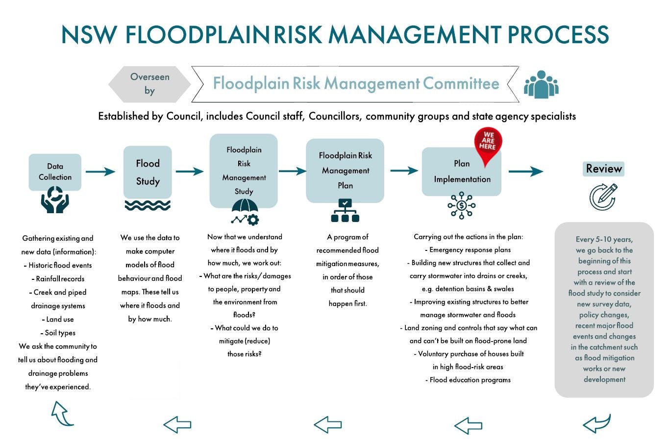
Read the FAQ, draft Report and have a look at the Floodplain Risk Management Process diagram to learn more about the Study, how we manage flood risk and what we will use the flood study information for, then share your feedback online with the project team.

Following our conversations with the community, the Kully Bay Overland Flow Study will go to Council for adoption. After that, we can start working on a Floodplain Risk Management Study that looks at what the risks and damages from floods might be, and what we could do to mitigate (reduce) those risks. We’ll again be inviting the community to contribute to that process when the time comes.

Feedback closes on 23 September 2019.

Consultation has concluded
  • Kully Bay Overland Flow Study (2019) adopted by Council on 28 October 2019

    Share on Facebook Share on Twitter Share on Linkedin Email this link

    The Kully Bay Overland Flow Study (2019) was finalised following the public exhibition and a report went to Council at the meeting on 28 October 2019. Councillors resolved unanimously to adopt the Study.

    The Study will inform land use planning, planning certificates and be used for the development of a floodplain risk management study and plan.

    Read the Business Paper and meeting minutes on Council's website for more information.

    Thank you to all who attended the information session. Your interest in Council's management of flood risk is highly valued.
  • Community input

    Share on Facebook Share on Twitter Share on Linkedin Email this link

    Council’s engagement team worked collaboratively with a technical consultant to share the draft Study with the community and key stakeholders. During the public exhibition period, 26 August to 23 September 2019, Council sent letters to more than 1,000 residents and property owners in the catchment area inviting them to learn more about the Study. Customer service information was included in the three most commonly-spoken languages in this area other than English; Macedonian, Italian and Arabic. The additional information let the community know that Council and the National Relay Service could provide language assistance if needed. Emails with this information were sent to community, education, Register of Interest (flood), business, government and emergency services’ stakeholders. The information was also available at Council’s Customer Service Centre. Copies of the draft report, a Frequently Asked Questions sheet and Feedback Form were made available at Warrawong Library, and at the information session at Warrawong Community Centre on 7 September 2019. They were also included on the project webpage, which also included a Google Translate feature to assist with online translation. Notices of the exhibition were published in the Advertiser on 28 August and 4 September 2019. The community were invited to provide feedback via this webpage, Customer Service Centre and at the community information session.

    There were no submissions, however some comments were provided at the drop-in information session which was attended by a total of 3 community members, including NSW State Emergency Service volunteers and a floodplain committee member.

    Feedback themes related to general interest about flood risk in the catchment. There was also interest in the flood gates at the entrance of Warrawong Mall.