Fairy & Cabbage Tree Creeks Catchment Flood Study
Consultation has concluded
As part of our commitment to managing flood and stormwater in our region, we’re working on a flood study for the Fairy & Cabbage Tree Creeks catchment. The updated Study explains the ways flooding happens in the Fairy & Cabbage Tree Creeks catchment, which covers an area between Towradgi and the southern end of Wollongong.

We’re sharing the draft Study with the community during the public exhibition from 6 April to 11 May 2020.
In line with NSW Health guidelines about Novel Coronavirus, we’ve made some changes to the way we’re engaging the community, to keep our staff and people in our community safe. Instead of having face-to-face conversations with people, we’re offering the following opportunities to learn more about the flood study and ask questions of the floodplain engineers who are working on it:
On this wepbage, you can
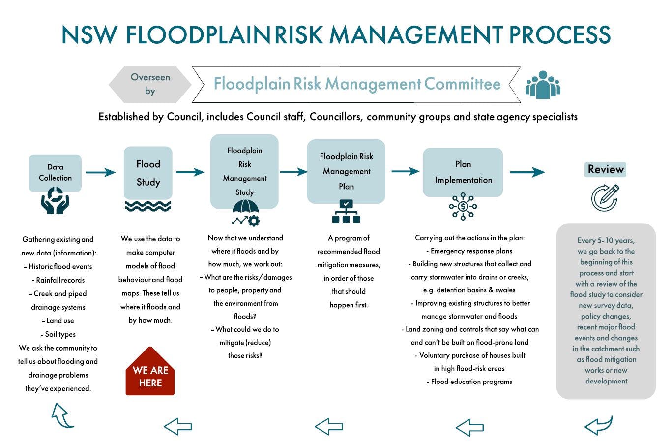
- Read the FAQ, draft report and have a look at the Floodplain Risk Management Process diagram to learn more about the Study, how we manage flood risk and what we will use the flood study information for
- View a presentation on the flood study report and flood-modelling results
- View short flood-modelling videos that help explain how it can flood in this catchment
- Take part in an online Q&A where our floodplain engineers will respond to your questions about the flood study
- Provide feedback on the flood study via the online form
In addition, you can email engagement@wollongong.nsw.gov.au to book in a time to speak to a flood engineer about the Study via phone or Skype.
Following our conversations with the community, the Fairy & Cabbage Tree Creeks Flood Study will go to Council for adoption. After that, we can start working on a Floodplain Risk Management Study that looks at what the risks and damages from floods might be, and what we could do to mitigate (reduce) those risks. We’ll again be inviting the community to contribute to that process when the time comes.
Feedback closes on 11 May 2020.
Please submit your questions about the flood study and we'll get back to you shortly with a response.
Signup Banner

Presentation on the Fairy and Cabbage Tree Creeks Flood Study
-
This presentation gives an overview of the Study, and provides an improved understanding of flooding in this catchment and its potential impacts.
Document Library
-
 Draft Fairy and Cabbage Tree Creeks Flood Study Volume 1 (53.4 MB) (pdf)
-
Draft Fairy and Cabbage Tree Creeks Flood Study Volume 2 Part 1 (40 MB) (pdf)
-
Draft Fairy and Cabbage Tree Creeks Flood Study Volume 2 Part 2 (40.3 MB) (pdf)
-
Draft Fairy and Cabbage Tree Creeks Flood Study Volume 2 Part 3 (45.6 MB) (pdf)
-
Wollongong's Flood History (1.3 MB) (pdf)
-
Maintenance of Urban Watercourses on Private Property Factsheet (60.7 KB) (pdf)