
Corrimal Coke Works Development Proposal
Consultation has concluded
Thanks for your interest in the Corrimal Coke Works Development Proposal.
Engagement on the proposal to rezone the site has now finished and all comments were presented to Councillors at the 1 November 2021 Council meeting. Council resolved at that meeting to finalise the Planning Proposal.
Amendment 50 of the Local Environment Plan (LEP) for the Corrimal Coke Works Site has been published by the NSW Department of Planning & Environment on Friday 29 April 2022 and the site has now been rezoned.
The eastern part of the site is now zoned R3 Medium Density Development to permit urban development and the western part is now RE1 Public Recreation.
On 6 June 2022 Council resolved to adopt a site-specific Development Control Plan Chapter, to guide future development of the site.
A Post exhibition report will also be completed on the Voluntary Planning Agreement (VPA).
On 29 June 2020, Council resolved to progress a heritage amendment to Wollongong LEP 2009 as a separate process to the rezoning Planning Proposal. The heritage amendment (Amendment 46) was notified on 11 September 2020, listing part of the site as a Local Heritage Item in Wollongong LEP 2009.
On 6 May 2022, listing on the State Heritage Register was published. Site-specific exemptions enable the demolition of the majority of the structures on site and the development of the site in accordance with the Planning Proposal / LEP amendment, Master Plan, Development Control Plan and any future development consent. The exhibited State Heritage listing boundary proposed that the whole site be listed. The final boundary has been reduced to be similar to the local heritage listing boundary included in the Wollongong LEP 2009
As a record the content on this page below relates to engagement undertaken prior to rezoning.
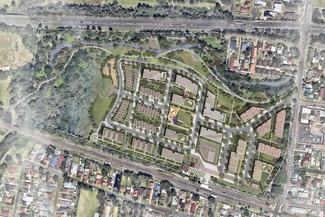
Illawarra Coke Company Pty Ltd and Legacy Property are seeking planning approval to rezone the former Corrimal Coke Works site located at 27 Railway Street Corrimal, to enable residential development, conservation and open space. As part of this process, Council is exhibiting the following documents for community comment:
- The draft Planning Proposal which seeks to rezone the site from IN3 Heavy Industrial and RE2 Private Recreation to R3 Medium Density Residential and RE1 Public Recreation to allow future medium density residential development. The draft Planning Proposal also proposes to increase the building height and floor space ratio controls, introduce a minimum lot size standard, amend some of the environmental mapping, and introduce site specific provisions.
- The draft Development Control Plan Chapter which contains guidelines and development controls that will be used in the assessment of any future development applications.
- A draft Planning Agreement Letter of Offer which outlines proposed community benefit outcomes to be incorporated into the proposed future development, some of which will offset development contributions. This Letter of Offer is inconsistent with Council’s resolution on 19 April 2021.
- Also on exhibition will be various technical studies, submitted in support of the application.
The Corrimal Coke Works draft Planning Proposal and package of information will be on exhibition from Friday 25 June to Tuesday 31 August 2021. The public exhibition period allows the community to view information about the draft Planning Proposal, draft Development Control Plan Chapter and Letter of Offer, and provide feedback.
Council’s role in the public exhibition process is to:
- Place the documents on our website and in our libraries
- Provide the community with the opportunity to attend an information session to learn about the plans
- Collect community feedback
- Review and incorporate the feedback into a Post-Exhibition Report for consideration at a future Council meeting.
Information sessions
Due to the NSW Health restrictions that are now in place to prevent the spread of COVID we are unable to conduct our face to face information sessions.
As a best possible alternative to continue our commitment to provide information on the Coke Works Development Proposal we are running online information sessions on Saturday 24, Monday 26 and Tuesday 27 July.
Times and booking links are:
- Saturday 24 July 2021 - 3.30 to 4.30pm: https://corrimal-cokeworks-24-july.eventbrite.com.au
- Monday 26 July 2021 - 4 to 5pm: https://corrimal-cokeworks-26-july.eventbrite.com.au
- Tuesday 27 July 2021 - 1.30 to 2.30pm: https://corrimal-cokeworks-27-july.eventbrite.com.au
All members of the public who have booked for the face to face sessions will be contacted and informed of the online process and times. We are also still taking bookings.
Everyone booked into the sessions will be sent a Microsoft teams link to their email address with instructions on how the sessions will work.
IF you have booked into the sessions or would like to book in and you do not have computer or internet access please contact Community Engagement on 4227 7111
Bookings are essential to manage attendee numbers.To attend an online information session, please make a booking online or you can phone (02) 4227 7238.

Council is monitoring the current roll-out of new COVID health orders and will make changes to consultation arrangements if necessary. At the present time, each information session will be limited to 40 minutes and 24 people per session to ensure they are COVID-safe. Anyone registered will be contacted if there are any changes. If you still have questions after the information session, you can write, email or phone us at Council.
Accessibility or mobility requirements
If you would like to attend and have accessibility or mobility requirements, please let us know how we can support your attendance. We can also arrange for an interpreter to come along to help residents who have difficulty communicating in English. To arrange support, please contact 4227 7238 by 19 July 2021.
How you can provide feedback on the Corrimal Coke Works Draft Planning Proposal
- Submit your comments through the feedback form
- Place a pin on the interactive map and make a comment
- Ask a question in the Q & A
- Send an email to records@wollongong.nsw.gov.au
- Write to General Manager, Wollongong City Council, Locked Bag 8821 Wollongong DC 2500
Please read Council's Privacy Notification before providing your feedback.
If you're deaf or have a hearing or speech impairment, you can contact us through the National Relay Service. If you need an interpreter you can contact us through the Translating and Interpreting Service on 131 450. You'll need to provide our phone number (02) 4227 7111 for either service.
Feedback closes on 31 August 2021
All feedback provided during the public exhibition period will be acknowledged, reviewed and considered. Council Planning Officers will then complete a Post-Exhibition Report that will be considered by Councillors at a Council Meeting. Please provide your feedback to Council prior to the closing date on 31 August 2021.
After the public exhibition period
Should Council resolve to finalise the draft Planning Proposal, the next step is for the NSW Department of Planning, Industry and Environment to formally finalise the Planning Proposal and to notify an amendment to the Wollongong Local Environmental Plan 2009. Mapping is changed to reflect the new zoning and related planning controls. If all of this happens, the applicant can then begin to lodge Development Applications for the site (there are engagement requirements if and when any Development Applications are lodged).
Thanks for your interest in the Corrimal Coke Works Development Proposal.
Engagement on the proposal to rezone the site has now finished and all comments were presented to Councillors at the 1 November 2021 Council meeting. Council resolved at that meeting to finalise the Planning Proposal.
Amendment 50 of the Local Environment Plan (LEP) for the Corrimal Coke Works Site has been published by the NSW Department of Planning & Environment on Friday 29 April 2022 and the site has now been rezoned.
The eastern part of the site is now zoned R3 Medium Density Development to permit urban development and the western part is now RE1 Public Recreation.
On 6 June 2022 Council resolved to adopt a site-specific Development Control Plan Chapter, to guide future development of the site.
A Post exhibition report will also be completed on the Voluntary Planning Agreement (VPA).
On 29 June 2020, Council resolved to progress a heritage amendment to Wollongong LEP 2009 as a separate process to the rezoning Planning Proposal. The heritage amendment (Amendment 46) was notified on 11 September 2020, listing part of the site as a Local Heritage Item in Wollongong LEP 2009.
On 6 May 2022, listing on the State Heritage Register was published. Site-specific exemptions enable the demolition of the majority of the structures on site and the development of the site in accordance with the Planning Proposal / LEP amendment, Master Plan, Development Control Plan and any future development consent. The exhibited State Heritage listing boundary proposed that the whole site be listed. The final boundary has been reduced to be similar to the local heritage listing boundary included in the Wollongong LEP 2009
As a record the content on this page below relates to engagement undertaken prior to rezoning.
Illawarra Coke Company Pty Ltd and Legacy Property are seeking planning approval to rezone the former Corrimal Coke Works site located at 27 Railway Street Corrimal, to enable residential development, conservation and open space. As part of this process, Council is exhibiting the following documents for community comment:
- The draft Planning Proposal which seeks to rezone the site from IN3 Heavy Industrial and RE2 Private Recreation to R3 Medium Density Residential and RE1 Public Recreation to allow future medium density residential development. The draft Planning Proposal also proposes to increase the building height and floor space ratio controls, introduce a minimum lot size standard, amend some of the environmental mapping, and introduce site specific provisions.
- The draft Development Control Plan Chapter which contains guidelines and development controls that will be used in the assessment of any future development applications.
- A draft Planning Agreement Letter of Offer which outlines proposed community benefit outcomes to be incorporated into the proposed future development, some of which will offset development contributions. This Letter of Offer is inconsistent with Council’s resolution on 19 April 2021.
- Also on exhibition will be various technical studies, submitted in support of the application.
The Corrimal Coke Works draft Planning Proposal and package of information will be on exhibition from Friday 25 June to Tuesday 31 August 2021. The public exhibition period allows the community to view information about the draft Planning Proposal, draft Development Control Plan Chapter and Letter of Offer, and provide feedback.
Council’s role in the public exhibition process is to:
- Place the documents on our website and in our libraries
- Provide the community with the opportunity to attend an information session to learn about the plans
- Collect community feedback
- Review and incorporate the feedback into a Post-Exhibition Report for consideration at a future Council meeting.
Information sessions
Due to the NSW Health restrictions that are now in place to prevent the spread of COVID we are unable to conduct our face to face information sessions.
As a best possible alternative to continue our commitment to provide information on the Coke Works Development Proposal we are running online information sessions on Saturday 24, Monday 26 and Tuesday 27 July.
Times and booking links are:
- Saturday 24 July 2021 - 3.30 to 4.30pm: https://corrimal-cokeworks-24-july.eventbrite.com.au
- Monday 26 July 2021 - 4 to 5pm: https://corrimal-cokeworks-26-july.eventbrite.com.au
- Tuesday 27 July 2021 - 1.30 to 2.30pm: https://corrimal-cokeworks-27-july.eventbrite.com.au
All members of the public who have booked for the face to face sessions will be contacted and informed of the online process and times. We are also still taking bookings.
Everyone booked into the sessions will be sent a Microsoft teams link to their email address with instructions on how the sessions will work.
IF you have booked into the sessions or would like to book in and you do not have computer or internet access please contact Community Engagement on 4227 7111
Bookings are essential to manage attendee numbers.To attend an online information session, please make a booking online or you can phone (02) 4227 7238.
Council is monitoring the current roll-out of new COVID health orders and will make changes to consultation arrangements if necessary. At the present time, each information session will be limited to 40 minutes and 24 people per session to ensure they are COVID-safe. Anyone registered will be contacted if there are any changes. If you still have questions after the information session, you can write, email or phone us at Council.
Accessibility or mobility requirements
If you would like to attend and have accessibility or mobility requirements, please let us know how we can support your attendance. We can also arrange for an interpreter to come along to help residents who have difficulty communicating in English. To arrange support, please contact 4227 7238 by 19 July 2021.
How you can provide feedback on the Corrimal Coke Works Draft Planning Proposal
- Submit your comments through the feedback form
- Place a pin on the interactive map and make a comment
- Ask a question in the Q & A
- Send an email to records@wollongong.nsw.gov.au
- Write to General Manager, Wollongong City Council, Locked Bag 8821 Wollongong DC 2500
Please read Council's Privacy Notification before providing your feedback.
If you're deaf or have a hearing or speech impairment, you can contact us through the National Relay Service. If you need an interpreter you can contact us through the Translating and Interpreting Service on 131 450. You'll need to provide our phone number (02) 4227 7111 for either service.
Feedback closes on 31 August 2021
All feedback provided during the public exhibition period will be acknowledged, reviewed and considered. Council Planning Officers will then complete a Post-Exhibition Report that will be considered by Councillors at a Council Meeting. Please provide your feedback to Council prior to the closing date on 31 August 2021.
After the public exhibition period
Should Council resolve to finalise the draft Planning Proposal, the next step is for the NSW Department of Planning, Industry and Environment to formally finalise the Planning Proposal and to notify an amendment to the Wollongong Local Environmental Plan 2009. Mapping is changed to reflect the new zoning and related planning controls. If all of this happens, the applicant can then begin to lodge Development Applications for the site (there are engagement requirements if and when any Development Applications are lodged).
If you have any questions about the proposal for the Corrimal Coke Works site please ask them here. We will answer all questions on Thursday every week.
-
Share My question is in regard to Page 11 of the document titled 'Draft Planning Proposal to Amend Wollongong LEP 2009'. The document states 'The retained heritage structures in the civic plaza are proposed to be managed in future private ownership as part of the retail offer, with Council not intending to take on ownership of this asset. ' Is the applicant responsible for the initial conservation works of the heritage items identified to be retained, conserved, and interpreted in the Conservation Management Strategy and Heritage Interpretation Strategy? If not, is money being set aside from the sale of the former CCW to set up a fund to this, and any possible shortfalls for an ongoing heritage maintenance program, particularly if residential uptake is slow, and subsequent retail uptake is slow (refer page 68 of the Master Plan). on Facebook Share My question is in regard to Page 11 of the document titled 'Draft Planning Proposal to Amend Wollongong LEP 2009'. The document states 'The retained heritage structures in the civic plaza are proposed to be managed in future private ownership as part of the retail offer, with Council not intending to take on ownership of this asset. ' Is the applicant responsible for the initial conservation works of the heritage items identified to be retained, conserved, and interpreted in the Conservation Management Strategy and Heritage Interpretation Strategy? If not, is money being set aside from the sale of the former CCW to set up a fund to this, and any possible shortfalls for an ongoing heritage maintenance program, particularly if residential uptake is slow, and subsequent retail uptake is slow (refer page 68 of the Master Plan). on Twitter Share My question is in regard to Page 11 of the document titled 'Draft Planning Proposal to Amend Wollongong LEP 2009'. The document states 'The retained heritage structures in the civic plaza are proposed to be managed in future private ownership as part of the retail offer, with Council not intending to take on ownership of this asset. ' Is the applicant responsible for the initial conservation works of the heritage items identified to be retained, conserved, and interpreted in the Conservation Management Strategy and Heritage Interpretation Strategy? If not, is money being set aside from the sale of the former CCW to set up a fund to this, and any possible shortfalls for an ongoing heritage maintenance program, particularly if residential uptake is slow, and subsequent retail uptake is slow (refer page 68 of the Master Plan). on Linkedin Email My question is in regard to Page 11 of the document titled 'Draft Planning Proposal to Amend Wollongong LEP 2009'. The document states 'The retained heritage structures in the civic plaza are proposed to be managed in future private ownership as part of the retail offer, with Council not intending to take on ownership of this asset. ' Is the applicant responsible for the initial conservation works of the heritage items identified to be retained, conserved, and interpreted in the Conservation Management Strategy and Heritage Interpretation Strategy? If not, is money being set aside from the sale of the former CCW to set up a fund to this, and any possible shortfalls for an ongoing heritage maintenance program, particularly if residential uptake is slow, and subsequent retail uptake is slow (refer page 68 of the Master Plan). link
My question is in regard to Page 11 of the document titled 'Draft Planning Proposal to Amend Wollongong LEP 2009'. The document states 'The retained heritage structures in the civic plaza are proposed to be managed in future private ownership as part of the retail offer, with Council not intending to take on ownership of this asset. ' Is the applicant responsible for the initial conservation works of the heritage items identified to be retained, conserved, and interpreted in the Conservation Management Strategy and Heritage Interpretation Strategy? If not, is money being set aside from the sale of the former CCW to set up a fund to this, and any possible shortfalls for an ongoing heritage maintenance program, particularly if residential uptake is slow, and subsequent retail uptake is slow (refer page 68 of the Master Plan).
Fiona Reynolds asked over 4 years agoThe Conservation Management Strategy and accompanying Heritage Interpretation Strategy provides for retention of the two chimney elements that “bookend” the C1 coke oven battery, designed to retain key iconic skyline elements of the coke works in the most visible locations, and partial retention of the C1 coke oven battery and the powerhouse building, combined with interpretation of other elements. It is the intention to establish a key view axis to the Brick Chimney. A key heritage strategy is fixing the Brick Chimney as the overall height limit (32.6 metres), while ensuring that significant retained and interpreted elements remain prominent for understanding and celebrating the history of the site.
The retained heritage structures in the civic plaza are proposed to be managed in future private ownership as part of the retail offer, with Council not intending to take on ownership of this asset.
Any requirements relating to conservation works and commitments to same would be conditioned as a requirement to any future Development Applications. These matters will be subject to further processes and require DA assessment (and potentially input by Heritage NSW if the site is State Heritage Register listed). Any comments on the Conservation Management Strategy and its recommended conservation outcomes are encouraged through the public engagement process.
-
Share I wish to ask numerous questions about a proposed rezoning and subsequent residential development of the former Corrimal Cokeworks site. 1. Can it be acknowledged that adding 550 dwellings to an already congested Corrimal, will significantly increase its population by up to 40%. 2. Is the proposed development is out of character and over development to the Corrimal Community? 3. What provision is to be made to increase and enhance the limited infrastructure to enable fundamental functioning of this proposed development? This includes roads, bridges, schools, access, parking, permanent services and utilities etc! 4. The pandemic has highlighted grave concerns about residential density in spreading infections. With this awareness will this development be dramatically scaled back especially in size, density and height? 5.The proposed development is jammed between a railway line and a major Wollongong "Expressway", Memorial Drive. Will It becomes a landlocked locality with only one narrow access/ egress road? 6. What is Services New South Wales guidelines for usual vehicle movements per dwelling each day. 7.With this immense increase in volume of traffic how will vehicles access and exit the proposed development and prevent it from becoming a virtual parking lot and prohibiting through traffic? 8. With an estimated 3000 plus traffic movements per day to and from the proposed development, how will this be catered for in this existing inadequate road structure? 9.Traffic is now and will be a significant problem creating critical congestion in a suburban road, Railway Street, with its traffic existing barriers at Memorial Drive and the railway line. What infrastructure is to be built to alleviate this horror? 10. Why is Railway Street the only access/ egress to the proposed development? 11. What provision is to be made for other access/ egress to the proposed development? 12. Why is there no bridge or tunnel stipulated to be constructed with the intersections of Railway Street and Memorial Drive and the railway line? 13. As there is only one entry exit what provision is to be made for emergencies? 14. The walking and bicycle paths in the proposed development do they exit at any other locality other than Railway Street? Are they paths to nowhere? 15. Massive traffic congestion and parking problems are to eventuate. How will traffic movements be regulated? 16. Can a condition of development (if it is to proceed) be a smaller Urban township with the prohibition of all vehicle traffic and no vehicles for residents? This will create an innovative township that will be an example to the world. Another Wollongong first! 17. What efforts are being made to identify and preserve indigenous heritage? 18. The site has been industrialised for over 100 years. What is to be done about the environmental contamination and removal of industrial waste and asbestos? 19.Environmental assessments need to be updated, they are over two years old. In regard to ecological factors a study dismissed the potential for for the Green and Gold Bullfrog to be present is scant. There appears to be no survey, merely a statement made that it was not thought to be a suitable habitat. When will a proper assessment /survey be undertaken? 20. The Microbat assessment should also be updated, particularly concerning the loss of habitat during the Blacksummer Bushfires. The assessment was undertaken prior to this horror event and needs to be updated as their was a huge habitat loss, making remaining habitat far more critical. When is this assessment to be undertaken? 21. Does the proposal conform to Legislation and International Conventions on threatened, endangered and migratary species? 22. Any development will destroy existing ecosystems. Why is this allowed? 23.The proposed development will cause destruction of the natural environment in the removal of trees and vegetation? Why is this allowed especially as it is in contradiction of Council's Urban Greening Policy and of Tree Preservation? 24. As it is a last area of natural coastal Forest and vegetation in the city how can it be preserved and enhanced? 25. The area is located on a floodplain intensified by the railway line and Memorial Drive? What provision is to be made to control this environmental hazard? 26. How can the ecosystems of Towradgi Creek be prevented from environmental disasters? 27. What are the strategies for preserving flora, fauna, ecosystems as well as indigenous and industrial heritage? How and when are they to be implemented? 28. What strategies are to be implemented to prevent lasting and irreparableable damage to the natural environment? 29. Legacy Property have established a sale office at Corrimal Court. Is this a gigantic presumption on their part and are they privy to information that is unavailable to the Community. on Facebook Share I wish to ask numerous questions about a proposed rezoning and subsequent residential development of the former Corrimal Cokeworks site. 1. Can it be acknowledged that adding 550 dwellings to an already congested Corrimal, will significantly increase its population by up to 40%. 2. Is the proposed development is out of character and over development to the Corrimal Community? 3. What provision is to be made to increase and enhance the limited infrastructure to enable fundamental functioning of this proposed development? This includes roads, bridges, schools, access, parking, permanent services and utilities etc! 4. The pandemic has highlighted grave concerns about residential density in spreading infections. With this awareness will this development be dramatically scaled back especially in size, density and height? 5.The proposed development is jammed between a railway line and a major Wollongong "Expressway", Memorial Drive. Will It becomes a landlocked locality with only one narrow access/ egress road? 6. What is Services New South Wales guidelines for usual vehicle movements per dwelling each day. 7.With this immense increase in volume of traffic how will vehicles access and exit the proposed development and prevent it from becoming a virtual parking lot and prohibiting through traffic? 8. With an estimated 3000 plus traffic movements per day to and from the proposed development, how will this be catered for in this existing inadequate road structure? 9.Traffic is now and will be a significant problem creating critical congestion in a suburban road, Railway Street, with its traffic existing barriers at Memorial Drive and the railway line. What infrastructure is to be built to alleviate this horror? 10. Why is Railway Street the only access/ egress to the proposed development? 11. What provision is to be made for other access/ egress to the proposed development? 12. Why is there no bridge or tunnel stipulated to be constructed with the intersections of Railway Street and Memorial Drive and the railway line? 13. As there is only one entry exit what provision is to be made for emergencies? 14. The walking and bicycle paths in the proposed development do they exit at any other locality other than Railway Street? Are they paths to nowhere? 15. Massive traffic congestion and parking problems are to eventuate. How will traffic movements be regulated? 16. Can a condition of development (if it is to proceed) be a smaller Urban township with the prohibition of all vehicle traffic and no vehicles for residents? This will create an innovative township that will be an example to the world. Another Wollongong first! 17. What efforts are being made to identify and preserve indigenous heritage? 18. The site has been industrialised for over 100 years. What is to be done about the environmental contamination and removal of industrial waste and asbestos? 19.Environmental assessments need to be updated, they are over two years old. In regard to ecological factors a study dismissed the potential for for the Green and Gold Bullfrog to be present is scant. There appears to be no survey, merely a statement made that it was not thought to be a suitable habitat. When will a proper assessment /survey be undertaken? 20. The Microbat assessment should also be updated, particularly concerning the loss of habitat during the Blacksummer Bushfires. The assessment was undertaken prior to this horror event and needs to be updated as their was a huge habitat loss, making remaining habitat far more critical. When is this assessment to be undertaken? 21. Does the proposal conform to Legislation and International Conventions on threatened, endangered and migratary species? 22. Any development will destroy existing ecosystems. Why is this allowed? 23.The proposed development will cause destruction of the natural environment in the removal of trees and vegetation? Why is this allowed especially as it is in contradiction of Council's Urban Greening Policy and of Tree Preservation? 24. As it is a last area of natural coastal Forest and vegetation in the city how can it be preserved and enhanced? 25. The area is located on a floodplain intensified by the railway line and Memorial Drive? What provision is to be made to control this environmental hazard? 26. How can the ecosystems of Towradgi Creek be prevented from environmental disasters? 27. What are the strategies for preserving flora, fauna, ecosystems as well as indigenous and industrial heritage? How and when are they to be implemented? 28. What strategies are to be implemented to prevent lasting and irreparableable damage to the natural environment? 29. Legacy Property have established a sale office at Corrimal Court. Is this a gigantic presumption on their part and are they privy to information that is unavailable to the Community. on Twitter Share I wish to ask numerous questions about a proposed rezoning and subsequent residential development of the former Corrimal Cokeworks site. 1. Can it be acknowledged that adding 550 dwellings to an already congested Corrimal, will significantly increase its population by up to 40%. 2. Is the proposed development is out of character and over development to the Corrimal Community? 3. What provision is to be made to increase and enhance the limited infrastructure to enable fundamental functioning of this proposed development? This includes roads, bridges, schools, access, parking, permanent services and utilities etc! 4. The pandemic has highlighted grave concerns about residential density in spreading infections. With this awareness will this development be dramatically scaled back especially in size, density and height? 5.The proposed development is jammed between a railway line and a major Wollongong "Expressway", Memorial Drive. Will It becomes a landlocked locality with only one narrow access/ egress road? 6. What is Services New South Wales guidelines for usual vehicle movements per dwelling each day. 7.With this immense increase in volume of traffic how will vehicles access and exit the proposed development and prevent it from becoming a virtual parking lot and prohibiting through traffic? 8. With an estimated 3000 plus traffic movements per day to and from the proposed development, how will this be catered for in this existing inadequate road structure? 9.Traffic is now and will be a significant problem creating critical congestion in a suburban road, Railway Street, with its traffic existing barriers at Memorial Drive and the railway line. What infrastructure is to be built to alleviate this horror? 10. Why is Railway Street the only access/ egress to the proposed development? 11. What provision is to be made for other access/ egress to the proposed development? 12. Why is there no bridge or tunnel stipulated to be constructed with the intersections of Railway Street and Memorial Drive and the railway line? 13. As there is only one entry exit what provision is to be made for emergencies? 14. The walking and bicycle paths in the proposed development do they exit at any other locality other than Railway Street? Are they paths to nowhere? 15. Massive traffic congestion and parking problems are to eventuate. How will traffic movements be regulated? 16. Can a condition of development (if it is to proceed) be a smaller Urban township with the prohibition of all vehicle traffic and no vehicles for residents? This will create an innovative township that will be an example to the world. Another Wollongong first! 17. What efforts are being made to identify and preserve indigenous heritage? 18. The site has been industrialised for over 100 years. What is to be done about the environmental contamination and removal of industrial waste and asbestos? 19.Environmental assessments need to be updated, they are over two years old. In regard to ecological factors a study dismissed the potential for for the Green and Gold Bullfrog to be present is scant. There appears to be no survey, merely a statement made that it was not thought to be a suitable habitat. When will a proper assessment /survey be undertaken? 20. The Microbat assessment should also be updated, particularly concerning the loss of habitat during the Blacksummer Bushfires. The assessment was undertaken prior to this horror event and needs to be updated as their was a huge habitat loss, making remaining habitat far more critical. When is this assessment to be undertaken? 21. Does the proposal conform to Legislation and International Conventions on threatened, endangered and migratary species? 22. Any development will destroy existing ecosystems. Why is this allowed? 23.The proposed development will cause destruction of the natural environment in the removal of trees and vegetation? Why is this allowed especially as it is in contradiction of Council's Urban Greening Policy and of Tree Preservation? 24. As it is a last area of natural coastal Forest and vegetation in the city how can it be preserved and enhanced? 25. The area is located on a floodplain intensified by the railway line and Memorial Drive? What provision is to be made to control this environmental hazard? 26. How can the ecosystems of Towradgi Creek be prevented from environmental disasters? 27. What are the strategies for preserving flora, fauna, ecosystems as well as indigenous and industrial heritage? How and when are they to be implemented? 28. What strategies are to be implemented to prevent lasting and irreparableable damage to the natural environment? 29. Legacy Property have established a sale office at Corrimal Court. Is this a gigantic presumption on their part and are they privy to information that is unavailable to the Community. on Linkedin Email I wish to ask numerous questions about a proposed rezoning and subsequent residential development of the former Corrimal Cokeworks site. 1. Can it be acknowledged that adding 550 dwellings to an already congested Corrimal, will significantly increase its population by up to 40%. 2. Is the proposed development is out of character and over development to the Corrimal Community? 3. What provision is to be made to increase and enhance the limited infrastructure to enable fundamental functioning of this proposed development? This includes roads, bridges, schools, access, parking, permanent services and utilities etc! 4. The pandemic has highlighted grave concerns about residential density in spreading infections. With this awareness will this development be dramatically scaled back especially in size, density and height? 5.The proposed development is jammed between a railway line and a major Wollongong "Expressway", Memorial Drive. Will It becomes a landlocked locality with only one narrow access/ egress road? 6. What is Services New South Wales guidelines for usual vehicle movements per dwelling each day. 7.With this immense increase in volume of traffic how will vehicles access and exit the proposed development and prevent it from becoming a virtual parking lot and prohibiting through traffic? 8. With an estimated 3000 plus traffic movements per day to and from the proposed development, how will this be catered for in this existing inadequate road structure? 9.Traffic is now and will be a significant problem creating critical congestion in a suburban road, Railway Street, with its traffic existing barriers at Memorial Drive and the railway line. What infrastructure is to be built to alleviate this horror? 10. Why is Railway Street the only access/ egress to the proposed development? 11. What provision is to be made for other access/ egress to the proposed development? 12. Why is there no bridge or tunnel stipulated to be constructed with the intersections of Railway Street and Memorial Drive and the railway line? 13. As there is only one entry exit what provision is to be made for emergencies? 14. The walking and bicycle paths in the proposed development do they exit at any other locality other than Railway Street? Are they paths to nowhere? 15. Massive traffic congestion and parking problems are to eventuate. How will traffic movements be regulated? 16. Can a condition of development (if it is to proceed) be a smaller Urban township with the prohibition of all vehicle traffic and no vehicles for residents? This will create an innovative township that will be an example to the world. Another Wollongong first! 17. What efforts are being made to identify and preserve indigenous heritage? 18. The site has been industrialised for over 100 years. What is to be done about the environmental contamination and removal of industrial waste and asbestos? 19.Environmental assessments need to be updated, they are over two years old. In regard to ecological factors a study dismissed the potential for for the Green and Gold Bullfrog to be present is scant. There appears to be no survey, merely a statement made that it was not thought to be a suitable habitat. When will a proper assessment /survey be undertaken? 20. The Microbat assessment should also be updated, particularly concerning the loss of habitat during the Blacksummer Bushfires. The assessment was undertaken prior to this horror event and needs to be updated as their was a huge habitat loss, making remaining habitat far more critical. When is this assessment to be undertaken? 21. Does the proposal conform to Legislation and International Conventions on threatened, endangered and migratary species? 22. Any development will destroy existing ecosystems. Why is this allowed? 23.The proposed development will cause destruction of the natural environment in the removal of trees and vegetation? Why is this allowed especially as it is in contradiction of Council's Urban Greening Policy and of Tree Preservation? 24. As it is a last area of natural coastal Forest and vegetation in the city how can it be preserved and enhanced? 25. The area is located on a floodplain intensified by the railway line and Memorial Drive? What provision is to be made to control this environmental hazard? 26. How can the ecosystems of Towradgi Creek be prevented from environmental disasters? 27. What are the strategies for preserving flora, fauna, ecosystems as well as indigenous and industrial heritage? How and when are they to be implemented? 28. What strategies are to be implemented to prevent lasting and irreparableable damage to the natural environment? 29. Legacy Property have established a sale office at Corrimal Court. Is this a gigantic presumption on their part and are they privy to information that is unavailable to the Community. link
I wish to ask numerous questions about a proposed rezoning and subsequent residential development of the former Corrimal Cokeworks site. 1. Can it be acknowledged that adding 550 dwellings to an already congested Corrimal, will significantly increase its population by up to 40%. 2. Is the proposed development is out of character and over development to the Corrimal Community? 3. What provision is to be made to increase and enhance the limited infrastructure to enable fundamental functioning of this proposed development? This includes roads, bridges, schools, access, parking, permanent services and utilities etc! 4. The pandemic has highlighted grave concerns about residential density in spreading infections. With this awareness will this development be dramatically scaled back especially in size, density and height? 5.The proposed development is jammed between a railway line and a major Wollongong "Expressway", Memorial Drive. Will It becomes a landlocked locality with only one narrow access/ egress road? 6. What is Services New South Wales guidelines for usual vehicle movements per dwelling each day. 7.With this immense increase in volume of traffic how will vehicles access and exit the proposed development and prevent it from becoming a virtual parking lot and prohibiting through traffic? 8. With an estimated 3000 plus traffic movements per day to and from the proposed development, how will this be catered for in this existing inadequate road structure? 9.Traffic is now and will be a significant problem creating critical congestion in a suburban road, Railway Street, with its traffic existing barriers at Memorial Drive and the railway line. What infrastructure is to be built to alleviate this horror? 10. Why is Railway Street the only access/ egress to the proposed development? 11. What provision is to be made for other access/ egress to the proposed development? 12. Why is there no bridge or tunnel stipulated to be constructed with the intersections of Railway Street and Memorial Drive and the railway line? 13. As there is only one entry exit what provision is to be made for emergencies? 14. The walking and bicycle paths in the proposed development do they exit at any other locality other than Railway Street? Are they paths to nowhere? 15. Massive traffic congestion and parking problems are to eventuate. How will traffic movements be regulated? 16. Can a condition of development (if it is to proceed) be a smaller Urban township with the prohibition of all vehicle traffic and no vehicles for residents? This will create an innovative township that will be an example to the world. Another Wollongong first! 17. What efforts are being made to identify and preserve indigenous heritage? 18. The site has been industrialised for over 100 years. What is to be done about the environmental contamination and removal of industrial waste and asbestos? 19.Environmental assessments need to be updated, they are over two years old. In regard to ecological factors a study dismissed the potential for for the Green and Gold Bullfrog to be present is scant. There appears to be no survey, merely a statement made that it was not thought to be a suitable habitat. When will a proper assessment /survey be undertaken? 20. The Microbat assessment should also be updated, particularly concerning the loss of habitat during the Blacksummer Bushfires. The assessment was undertaken prior to this horror event and needs to be updated as their was a huge habitat loss, making remaining habitat far more critical. When is this assessment to be undertaken? 21. Does the proposal conform to Legislation and International Conventions on threatened, endangered and migratary species? 22. Any development will destroy existing ecosystems. Why is this allowed? 23.The proposed development will cause destruction of the natural environment in the removal of trees and vegetation? Why is this allowed especially as it is in contradiction of Council's Urban Greening Policy and of Tree Preservation? 24. As it is a last area of natural coastal Forest and vegetation in the city how can it be preserved and enhanced? 25. The area is located on a floodplain intensified by the railway line and Memorial Drive? What provision is to be made to control this environmental hazard? 26. How can the ecosystems of Towradgi Creek be prevented from environmental disasters? 27. What are the strategies for preserving flora, fauna, ecosystems as well as indigenous and industrial heritage? How and when are they to be implemented? 28. What strategies are to be implemented to prevent lasting and irreparableable damage to the natural environment? 29. Legacy Property have established a sale office at Corrimal Court. Is this a gigantic presumption on their part and are they privy to information that is unavailable to the Community.
John Costello asked over 4 years agoWe can provide the following answers to your questions John.
1. Can it be acknowledged that adding 550 dwellings to an already congested Corrimal, will significantly increase its population by up to 40%.
Based on Council’s annual rate notice file for 2021/2022, there are approximately 2,973 households in the suburb of Corrimal. The 2016 Census recorded 6,519 people in Corrimal. The proposal is for an additional 550 dwellings. The economic studies submitted estimated that the higher number of 725 dwellings originally requested translated into approximately 1450 residents when fully developed.
2. Is the proposed development is out of character and over development to the Corrimal Community?
The site is surrounded by low and medium density residential zoning to the north, north-east and east, with some light industrial uses immediately to the north. Open space adjoins the site to the south. The maximum height limit for the site is currently nine (9) metres and the maximum height limit of the adjoining residential areas ranges from nine (9) metres to 13 metres.
The site is currently zoned for heavy industrial uses. The Planning Proposal seeks to rezone the 18-hectare site to R3 Medium Density Residential (noting that the character of the immediate area is predominantly residential) with height limits ranging from 9 to 15 metres, to permit 550 dwellings.
3. What provision is to be made to increase and enhance the limited infrastructure to enable fundamental functioning of this proposed development? This includes roads, bridges, schools, access, parking, permanent services and utilities etc!
A Servicing Strategy Report is one of the documents on exhibition. This Report states that the proposed development can be serviced by the existing network infrastructure and planned network upgrades.
Council collects contributions from developers to help fund public infrastructure that is required as a direct or indirect result of development. Contributions are used to fund infrastructure projects that benefit the public like roads, bridges, footpaths, community centres, parks, and sportsgrounds.
Development contributions are in addition to building and development costs outlined in our Fees and Charges. The amount payable will be based on the type, cost and location of the development. Development Contributions are included as a condition in the development consent. A Planning Agreement Letter of Offer has been received from the applicant and is on exhibition for comment.
4. The pandemic has highlighted grave concerns about residential density in spreading infections. With this awareness will this development be dramatically scaled back especially in size, density and height?
The proposal on exhibition has not changed since the Council resolution on 19 April 2021.
5.The proposed development is jammed between a railway line and a major Wollongong "Expressway", Memorial Drive. Will It becomes a landlocked locality with only one narrow access/ egress road?
The current proposal includes one access to the site, via a proposed roundabout at Railway Street and Harbinger Street. The dimensions of the access road facilitate bus and service vehicle (e.g., garbage trucks, fire engine) movements.
6. What is Services New South Wales guidelines for usual vehicle movements per dwelling each day.
As agreed with Roads and Maritime, the traffic generation rates applied to each land use were taken from the Roads and Maritime Services Guide to Traffic Generating Developments (GTTGD) (2002) and the Technical Direction Guide to Traffic Generating Developments Updated traffic surveys (TD13-04a). The adopted traffic generation rates were:
- Townhouses: 0.65 trips per dwelling per hour (TD13-04a);
- Apartments (regional rates near a train station): AM peak = 0.21 trips per bedroom per hour and PM peak 0.15 trips per bedroom per hour (TD13-04a);
- Retail: based on the GTTGD (2002);
- Housing for Seniors: 0.4 trips per dwelling per hour (TD13-04a); and
- Aged Care Facilities: with no specific rates in the GTTGD, the trip generation rates have been taken from ITE Generation Rates (Nursing Home 620). Trip generation rates for the AM peak = 0.17 per hour per bed and PM peak = 0.22 per hour per bed. Additionally, trip generation rates per employee for the AM peak = 0.22 per hour and PM peak = 0.8 per hour.
For answers to Q7, 8, 9, 10, 11, 12, 13 and 15,** please refer to the following documents on Council’s exhibition web page for information on these aspects of the proposal:
- Corrimal Coke Works Planning Proposal Summary – Traffic Assessment
- Additional Traffic Summary
7.With this immense increase in volume of traffic how will vehicles access and exit the proposed development and prevent it from becoming a virtual parking lot and prohibiting through traffic?
8. With an estimated 3000 plus traffic movements per day to and from the proposed development, how will this be catered for in this existing inadequate road structure?
9.Traffic is now and will be a significant problem creating critical congestion in a suburban road, Railway Street, with its traffic existing barriers at Memorial Drive and the railway line. What infrastructure is to be built to alleviate this horror?
10. Why is Railway Street the only access/ egress to the proposed development?
11. What provision is to be made for other access/ egress to the proposed development?
12. Why is there no bridge or tunnel stipulated to be constructed with the intersections of Railway Street and Memorial Drive and the railway line?
13. As there is only one entry exit what provision is to be made for emergencies?
15. Massive traffic congestion and parking problems are to eventuate. How will traffic movements be regulated?
16. Can a condition of development (if it is to proceed) be a smaller Urban township with the prohibition of all vehicle traffic and no vehicles for residents? This will create an innovative township that will be an example to the world. Another Wollongong first!
For answers to Q7, 8, 9, 10, 11, 12, 13 and 15, above** please refer to the following documents on Council’s exhibition web page for information on these aspects of the proposal:
- Corrimal Coke Works Planning Proposal Summary – Traffic Assessment
- Additional Traffic Summary
14. The walking and bicycle paths in the proposed development do they exit at any other locality other than Railway Street? Are they paths to nowhere?
A bicycle/walking shared path is proposed linking Railway Street through the site to the Council
owned open space south of the site. A pedestrian and cycle route upgrade along Railway Street and an internal cycling/pedestrian network is planned, to provide enhanced linkage opportunities between Corrimal Railway Station and the town centre and community facilities.
17. What efforts are being made to identify and preserve indigenous heritage?
The Aboriginal Cultural Heritage Assessment (Kelleher Nightingale May 2019) determined that one Aboriginal archaeological site comprising Aboriginal objects is located on site. The Kelleher Nightingale report states that “the entirety of the site would be impacted by the proposed redevelopment works” and hence will require an Aboriginal Heritage Impact Permit issued by OEH prior to any activity. On site consultation between registered Aboriginal stakeholders (13 Aboriginal community groups and individuals) and the proponent held 14 April 2019 has identified that the creeklines and adjacent areas have tangible Aboriginal cultural value associated with the use of these areas by past Aboriginal people for acquiring aquatic and terrestrial resources. The Illawarra Local Land Council has commented on the proposal, noting the cultural significance of the Towradgi Creek waterway through the site has been realigned. The potential for archaeological deposits associated with the intensive use of the waterway for Aboriginal fishing and food gathering activities in the former filled in creek corridor was identified and the request made for further Aboriginal Community consultation in progressing the overall Planning Proposal. The Planning Proposal and Aboriginal Cultural Heritage Assessment are being reviewed by relevant Aboriginal Groups in the community as part of the exhibition.
18. The site has been industrialised for over 100 years. What is to be done about the environmental contamination and removal of industrial waste and asbestos?
Please refer to the following document on Council’s exhibition web page for information on these aspects of the proposal:
"Corrimal Coke Works Planning Proposal Summary – Contamination"
19.Environmental assessments need to be updated; they are over two years old. In regard to ecological factors a study dismissed the potential for for the Green and Gold Bullfrog to be present is scant. There appears to be no survey, merely a statement made that it was not thought to be a suitable habitat. When will a proper assessment /survey be undertaken?
Any future development applications will require the submission of updated studies, including environmental assessments. The potential for Green and Golden Bell Frog was investigated in the Flora and Fauna Assessment (EcoLogical 2019) in relation to the two dams on site and the riparian corridor, given that there are recorded sightings approximately 1km to the east associated with Bellambi Lagoon. The assessment indicated that the preferred habitat for the Green and Golden Bell Frog are small and shallow ephemeral pools containing sedges or rushes which form fringing vegetation, sunny bank areas, and refuge and basking habitat in the form of rocks and woody debris. The study concluded that the site does not contain potential habitat for the Green and Golden Bell Frog.
20. The Microbat assessment should also be updated, particularly concerning the loss of habitat during the Blacksummer Bushfires. The assessment was undertaken prior to this horror event and needs to be updated as their was a huge habitat loss, making remaining habitat far more critical. When is this assessment to be undertaken?
Targeted survey for threatened microchiropteran bats (microbats) was conducted throughout the study area, with seven buildings and two rows of coke ovens assessed for potential habitat. The survey stated that no threatened microbats were detected and concluded that they are unlikely to utilise the resources of the subject site.
Following the Council resolution (8 April 2018), a further site inspection of all buildings was undertaken by EcoLogical to determine their use by microbats or suitability as microbat habitat. In a letter dated 22 July 2019, the conclusion drawn was there is a lack of suitable habitat, absence of signs of use or occupation and lack of records from previous ultrasonic detection surveys, indicating “that microbats rarely if ever use the structures, and if they ever do, it is only very occasionally and in small numbers”. The letter did acknowledge that is it possible that there may be occasional use of buildings by individual microbats in other seasons of the year, and hence recommended that an ecologist with demonstrated experience in locating microbats inspect structures prior to any demolition and be present during demolition to respond to the presence of any microbats.
Council Officer assessment is that there is potential for threatened microbats to utilise the subject site for roosting and foraging, and hence any demolition applied for will be subject to further assessment in this regard.
22. Does the proposal conform to Legislation and International Conventions on threatened, endangered and migratary species?
One threatened fauna species, Pteropus poliocephalus (Grey-headed Flying-fox) was found occupying a small patch of Forest Red Gum Thin-leaved Stringybark Grassy Woodland adjacent the dam and existing riparian corridor area at the southern extent of the study area in the EcoLogical 2017 study. The GHFF is listed as vulnerable under both the Biodiversity Conservation Act 2016 and Environment Protection and Biodiversity Conservation Act 1999. It is listed as a threatened species because their numbers have rapidly declined over a relatively short period of time and in recognition of their essential ecological role in pollination and seed dispersal.
The proposal includes a 100-metre buffer between the core camp and any future residential development and the preparation of a Camp Management Plan for the protection of the GHFF camp.
Answers for the questions 22, 23, 24, 27 and 28 are combined below*
22. Any development will destroy existing ecosystems. Why is this allowed?
23.The proposed development will cause destruction of the natural environment in the removal of trees and vegetation? Why is this allowed especially as it is in contradiction of Council's Urban Greening Policy and of Tree Preservation?
24. As it is a last area of natural coastal Forest and vegetation in the city how can it be preserved and enhanced?
28. What strategies are to be implemented to prevent lasting and irreparableable damage to the natural environment?
27. What are the strategies for preserving flora, fauna, ecosystems as well as indigenous and industrial heritage? How and when are they to be implemented?
*Answers for the questions 22, 23, 24, 27 and 28 are combined below.
The Flora and Fauna reports undertaken by EcoLogical in 2017 and 2019 identified that the vast majority of the site supported areas of cleared land (roads, infrastructure, water bodies) or weeds/exotics. The site has a long history of disturbance associated with its use as a Coke Works and it was noted that the vegetation communities across the site have been subjected to moderate to high levels of disturbance including vegetation clearing/thinning of canopy layer, infestation of exotic species and modification of landform and soil profiles.
Two patches of Illawarra Lowlands Grassy Woodland have been identified on the site – one in the north and one in the south. Although the patches are identified as EEC and considered a high ecological constraint, the Forest Red Gum Thin-leaved Stringybark Grassy Woodlands was identified as being in a highly modified and disturbed condition with high levels of exotic species, planted non-local native species present and modified landforms within the area of this community. The report concluded that neither of the patches present met the Environment Protection and Biodiversity Conservation Act 1999 definition of the community because the groundcover was <30% native. Although the vegetation in the north of the site has high conservation status (EEC), its conservation significance is low to moderate based on patch size, current and proposed future surrounding land use and the ongoing impacts that are likely to prevail.
It should be noted that the initial ecological report submitted with the draft Planning Proposal request (EcoLogical 2017) included the mapping of Moist Blue Gum Blackbutt Forest in the south of the site. Council received submissions from community members in response to this initial vegetation mapping, speculating about the presence of a patch of ‘rare rainforest’. To respond to community concerns Council agreed to follow up and inspect the patch of vegetation in question. Prior to Council’s site inspection, EcoLogical undertook more detailed vegetation surveys according to the Biodiversity Assessment Method including plot based floristic, structure and condition assessments and subsequently revised the initial vegetation mapping. Following the joint site inspection with the EcoLogical ecologists, including discussion on the rationale for the revised assessment, it was agreed that the area should be mapped Forest Red Gum Thin-leaved Stringybark Grassy Woodland.
The EcoLogical report (2019) states that any future Development Application stage will require the submission of a Biodiversity Development Assessment Report (BDAR), due to the proposed impacts (clearing) to native vegetation. The BDAR would be prepared consistent with the Biodiversity
Assessment Methodology and outline the offset requirements associated with the proposal. The EcoLogical report recommends at DA stage the preparation of a Vegetation Management Plan for the patches of vegetation to be retained and for the riparian corridor to be revegetated. The Vegetation Management Plan would be prepared consistent with DPI Water “Guidelines for vegetation management plans on waterfront land”, including consideration of bushfire risks, Council requirements and proposed landscaping. The proposed rezoning would retain and restore the EEC in the south of the site.
The State Government OEH submission (2017) also stressed avoidance of impacts upon threatened species and ecological communities and noted that clearing thresholds under the Biodiversity Conservation Act relate to the clearing of all native vegetation, not just EECs. Where development proposals affect remnant vegetation, the framework identifies a three-step process to ensure an overall increase in the extent and quality of native vegetation –
- Avoid adverse impact resulting in vegetation clearance.
- Where impact cannot be avoided, minimise impact through careful planning, design and
- management.
- Offset any vegetation loss through appropriate offsets, including planting more trees or vegetation.
Wollongong Development Control Plan is a set of Council policies that explain how developments need to be designed to meet the conditions of the Local Environmental Plan and state wide rules. Chapter E17 of the Wollongong Development Control Pan explains how trees and vegetation need to be protected during development.
The Biosis (2017) assessment concludes that the proposal to rezone the site for residential and commercial use represents the most viable option in terms of enhancing the heritage values, by making the history of the Coke Works accessible to the local community and the Illawarra through adaptive reuse and interpretation. The elements which comprise the Coke Works contribute to varying degrees to this significance, the most important components being the C1 coke battery and the powerhouse chimney which have been assessed as having a high level of significance. The Conservation Management Strategy and accompanying Heritage Interpretation Strategy provides for retention of the two chimney elements that “bookend” the C1 coke oven battery, designed to retain key iconic skyline elements of the coke works in the most visible locations, and partial retention of the C1 coke oven battery and the powerhouse building, combined with interpretation of other elements. It is the intention to establish a key view axis to the Brick Chimney. A key heritage strategy is fixing the Brick Chimney as the overall height limit (32.6 metres), while ensuring that significant retained and interpreted elements remain prominent for understanding and celebrating the history of the site.
The retained heritage structures in the civic plaza are proposed to be managed in future private ownership as part of the retail offer, with Council not intending to take on ownership of this asset
Heritage Amendment Planning Proposal progressed separately. Listing the site as a local heritage item in Wollongong LEP 2009 was endorsed by Council 29 June 2020 and the Heritage Amendment was notified on 11 September 2020. The CDC for demolition works has since been surrendered.
Potential for listing on the State Heritage Register is under assessment by Heritage NSW.
25. The area is located on a floodplain intensified by the railway line and Memorial Drive? What provision is to be made to control this environmental hazard?
Answers to questions 25 and 26 are combined below.
26. How can the ecosystems of Towradgi Creek be prevented from environmental disasters?
The form and alignment of the existing North Corrimal Creek on site has been substantially modified in the past as a result of site filling and construction of online dams associated with previous industrial uses. A key component of the Planning Proposal request is the proposed realignment of the existing 2nd order stream (North Corrimal Creek) to the western boundary of the site to alleviate local flooding issues and to provide a suitable flood free area to support the intended medium density residential development outcomes.
Significant modelling of a conceptual flood way has been undertaken. The updated Flood and
Geomorphological studies incorporate modelling of future flood events and conclude that a realigned riparian corridor can be provided along the western edge of the site such that flood risk levels currently present on site can be significantly mitigated to enable a Probable Maximum Flood (PMF) event free area suitable for residential development, and adjoining lands up and downstream will have an improved or neutral impact. The current Coke Works proposal is consistent with the Towradgi Creek Flood Study, and as the Towradgi Creek Floodplain Risk Management process continues, the Coke Works site will be included in future Council modelling.
29. Legacy Property have established a sale office at Corrimal Court. Is this a gigantic presumption on their part and are they privy to information that is unavailable to the Community.
Council has been advised that Legacy intended to operate a Community Information Centre in Corrimal, which has subsequently been changed to a Virtual Community Information Centre, given Covid restrictions.
-
Share I've read through the traffic reports which are very detailed and at times difficult to understand. In Councils report, Council concluded that the 'traffic impacts have been modelled and can be managed to provide appropriate levels of service." Can you please explain in plain English the findings of the various traffic assessments and the work Council completed so we can better understand the facts? on Facebook Share I've read through the traffic reports which are very detailed and at times difficult to understand. In Councils report, Council concluded that the 'traffic impacts have been modelled and can be managed to provide appropriate levels of service." Can you please explain in plain English the findings of the various traffic assessments and the work Council completed so we can better understand the facts? on Twitter Share I've read through the traffic reports which are very detailed and at times difficult to understand. In Councils report, Council concluded that the 'traffic impacts have been modelled and can be managed to provide appropriate levels of service." Can you please explain in plain English the findings of the various traffic assessments and the work Council completed so we can better understand the facts? on Linkedin Email I've read through the traffic reports which are very detailed and at times difficult to understand. In Councils report, Council concluded that the 'traffic impacts have been modelled and can be managed to provide appropriate levels of service." Can you please explain in plain English the findings of the various traffic assessments and the work Council completed so we can better understand the facts? link
I've read through the traffic reports which are very detailed and at times difficult to understand. In Councils report, Council concluded that the 'traffic impacts have been modelled and can be managed to provide appropriate levels of service." Can you please explain in plain English the findings of the various traffic assessments and the work Council completed so we can better understand the facts?
Justine48 asked over 4 years agoThanks for your questions Justin. The information below should answer both questions.
Modelling Traffic Generation
Extensive modelling was undertaken to better understand the likely impacts of the proposed
development on the surrounding roads, including the rail level crossing. The VISSIM Model was
developed for the 2018 AM and 2018 PM peak traffic conditions, calibrated and validated. The 2018 base model was then used to create the year 2026 base models, which is the estimated year of full development of the site. The 2026 traffic demands base model was created by adding the expected growth in background traffic to the traffic expected to be generated by the development (DA-2010/1562) opposite at 54-62 Railway Street and 10 Harbinger St, comprising 60 residential units and six villa homes. The Coke Works site expected development was then added into the model to arrive at the “2026 Base with Development” traffic demands for the area. Traffic signal timing and phasing at signalised intersections was replicated in the modelling from SCATS data provided by the RMS. The effects of the rail level crossing were also replicated in the model through video footage of peak period operations cross referenced with boom gate opening and closing data provided by Sydney Trains.
In line with the Council resolution, RMS traffic generation rates were applied to each land use, to calculate the site’s expected traffic generation. The impact assessment methodology/modelling was based on a “no worsening approach”, which involved ensuring that the “2026 with development” case impacts were sufficiently mitigated by upgrade works such that the “2026 with development + upgrades” case intersection was no worse that the “2026 Base” case.
Intersection levels of service (LoS) were modelled in line with the following criteria:
Table: Intersection Levels of Service
LoS Level
Delay Range (seconds)
Typical Intersection Operations
A
<14
Good operation
B
15 to 28
Good with acceptable delays and spare capacity
C
29 to 42
Satisfactory
D
43 to 56
Operating near capacity
E
57 to 70
At capacity
F
70 and above
Unsatisfactory
The additional traffic introduced into Railway Street by the development was found to equate to one vehicle every 10 seconds (two-way) in the peak hour, which is deemed insignificant on a distributor road such as Railway Street. The study showed an approximate 17% increase in daily traffic on Railway Street. The Traffic Impact Assessment (TIA) predicts 373 vehicle trips in the AM peak time and 456 trips in the PM peak. Overall, the modelling revealed that the current intersection and link configurations will accommodate the additional traffic generated between 2018 and 2026 with most of the key intersections expected to retain a similar level of service in 2026 with or without the additional development. However, during the AM peak, the Memorial Drive/Railway Street intersection is the location most affected by the development’s traffic, operating with a LoS D and average delay of 55.7 seconds (i.e. “operating at near capacity”).
The proposed access to the development site operates with a LoS C and delay of 42 seconds. During the PM peak, the Memorial Drive/Railway Street intersection is expected to operate at a LoS E and an average delay of 62.9 seconds (i.e. “at capacity”). The TIA proposes a traffic capacity upgrade at the Memorial Drive/Railway Street intersection to address the abovementioned congestion/queuing impacts anticipated to be generated by the development.
TfNSW has completed an assessment of the Planning Proposal from a State road network perspective and has indicated they are comfortable with the methodology used in the TIA. TfNSW notes –
- Memorial Drive and the surrounding local roads currently experience high traffic demands in the AM, PM and weekend peaks, particularly around the intersections of Memorial Drive with Towradgi Road, Railway Street and Rothery Street.
- The Planning Proposal would facilitate development which would generate a significant number of vehicle movements (373 vehicle trips in the AM peak and 456 PM peak).
- Traffic modelling has been undertaken to inform the Planning Proposal, with minor upgrades
- proposed at the Memorial Drive/Railway Street intersection to offset traffic impacts.
TfNSW has concluded, based on the wider review from a State road network perspective, that major upgrades will be required at a number of intersections on Memorial Drive in the future to accommodate existing high traffic demands and continuing growth in the area. TfNSW has proposed the following way forward –
- A monetary contribution, through a Planning Agreement or other mechanism, from the proponent towards major upgrades to Memorial Drive at three intersections (i.e. Towradgi Road, Railway Street and Rothery Street).
- Consideration to local road connections around the broader precinct to reduce the number of movements and/or conflicts at intersections along Memorial Drive and, where appropriate and reasonable, delivery of these connections or planning to preserve these connections as options for the future. For example, consideration to a local road connection between the site and Cross Street. Such a connection could enable the existing junction of Railway Street and Cross Street to be closed, thereby reducing conflicts at the intersection of Memorial Drive and Railway Street and removing a significant constraint to a major upgrade at this location. TfNSW would support the cost of any such connection being offset from the above monetary contribution. TfNSW believes a working group consisting of Council, the proponent and TfNSW be formed to examine local road connections.
- Planning controls (i.e. as part of the DCP) to minimise residential parking on the site, consistent with the provisions of Section 7.4 of the existing Council DCP, recognising the close proximity of the site to public transport.
- The early provision (by the proponent) of shared paths internal and external to the site to increase the attractiveness of walking and cycling for future residents of this site and existing residents in the surrounding area. The design of the network needs to promote walking and cycling to key locations above driving a car. Key locations include the railway station, the bus stops, the town centre, schools, other existing residential catchments, existing shared paths etc. The provision of broader network paths/active transport will reduce the vehicle trip demand on Memorial Drive.
- Appropriate arrangements in and around the site to increase the attractiveness of public transport (both rail and buses).
- Noise mitigation measures (as required) within the site to mitigate traffic noise from Memorial Drive.
TfNSW has no objections to the planning proposal going on public exhibition.
Access
It should be noted that the original 2017 Concept included two access points to Railway Street however, with the proposed transfer of Lot 126 DP 598190 to Council for the future rail bridge the number of intersections in the concept plan have been reduced to one. The proposed second access point would interfere with the location of a future overpass.
The Traffic Impact Assessment (Bitzios 2019) proposed access to the site via a single intersection off Railway Street, approximately 60 metres east of Harbinger Street and approximately 210 metres west of the rail line level crossing. The area has a posted speed limit of 50 km/h. Traffic Modelling confirms that the access intersection can operate efficiently as a channelised “T” intersection with a right turn-in pocket and separate left turn-out and right turn-out lanes, sufficiently catering for entry and exit queues without interrupting through traffic on Railway Street and without queuing back to Harbinger Street intersection. Safe intersection sight distance can be achieved in accordance with Austroads requirements.
Council Officers requested an additional access point be investigated (e.g. Memorial Drive), and the Design Review Panel also raised concern about the single point of vehicle access – “the single point of vehicle access may create safety issues on a development of this scale. If this entry point is blocked (road works, traffic accident, fire) there should be an alternative point of access and egress”. The DRP also noted the importance of ensuring that the vehicular access point connecting to the railway carpark is operational.
Council Officers have recommended one consolidated access point on Railway Street from a traffic safety and capacity perspective – this will result in less vehicle friction and turning movements and hence fewer delays and reduce the number of conflict points where accidents could occur. The fewer access points also assist in providing pedestrian/cyclist priority on the Railway Street shared path. To address the DRP concerns, the Council Traffic Officer recommendation is the consideration of a wide green/pedestrian/cyclist link into the site, which could double as an emergency access (emergency services can mount the kerb if needed to access the development).
Council Officers have raised concerns over the proposed access location on Railway Street, with offset/staggered intersections identified as a sub-optimal outcome. Following further discussion with the TfNSW Roads and Maritime Services, the recommendation was that a consolidated single-lane roundabout at the intersection of Railway and Harbinger Streets would be the preferred approach to access the site, subject to traffic modelling demonstrating no negative traffic impact on the Memorial Drive/Railway Street intersection. A consolidated single lane roundabout at that location would offer a number of safety outcomes as per the Safe System Approach (National Road Safety Strategy) and avoid potential problems inherent in the offset/staggered intersection proposal -
- Calm traffic.
- Provide a more convenient/shorter pedestrian crossing distance.
- The offset/staggered intersection arrangement would require the removal of substantial amounts of residential and visitor parking on Railway Street.
- The offset/staggered intersection arrangement would result in difficulties for drivers attempting to make a right hand turn out of Harbinger Street, as well as the proposed off set development road, resulting in traffic inefficiencies and safety concerns.
Subsequent traffic modelling (Bitzios 2019) has confirmed that a single-lane roundabout at the
intersection of Railway and Harbinger Streets performs at a LoS A with an average delay of 7 seconds for both morning and afternoon peak periods and has no negative queuing impact to the Memorial Drive intersection with Railway Street or the railway level crossing. The RMS is supportive of a roundabout at this location.
Should a Harbinger Street roundabout be deemed the most suitable access point for the development, then all of the EEC in the north would be unable to be retained due to direct and indirect impacts during construction and then over time, and hence an offset policy/arrangement would be required. It should be noted that although the vegetation in the north of the site in the vicinity of this proposed access point has high conservation status (EEC), its conservation significance is low to moderate based on patch size, current and proposed surrounding land use and the ongoing impacts that are likely to prevail. There is a mechanism by which Biodiversity loss can be offset (NSW Biodiversity Offset Scheme) whereby the entire 0.59 ha would be considered as lost to development through direct and indirect impacts.
A proposal for an additional left in/left out access off Memorial Drive approximately 480 metres south of its intersection with Railway Street was investigated however not deemed appropriate for the following reasons –
- It would introduce another intersection onto a road which has limited access, impacting its
- primary through-traffic carrying function and potentially traffic safety.
- It would require long deceleration and acceleration lanes in an 80 km/h speed environment.
- It may introduce weave conflicts associated with movements into turn pockets at the Towradgi
- Road intersection.
- It was not supported by RMS.
-
Share The Council report states that Council officers have "recommended one consolidated access point on Railway Street from a traffic safety and capacity perspective" Can you please explain in simple to understand language why Council believes only one access is needed on Railway Street and why it should be a roundabout? on Facebook Share The Council report states that Council officers have "recommended one consolidated access point on Railway Street from a traffic safety and capacity perspective" Can you please explain in simple to understand language why Council believes only one access is needed on Railway Street and why it should be a roundabout? on Twitter Share The Council report states that Council officers have "recommended one consolidated access point on Railway Street from a traffic safety and capacity perspective" Can you please explain in simple to understand language why Council believes only one access is needed on Railway Street and why it should be a roundabout? on Linkedin Email The Council report states that Council officers have "recommended one consolidated access point on Railway Street from a traffic safety and capacity perspective" Can you please explain in simple to understand language why Council believes only one access is needed on Railway Street and why it should be a roundabout? link
The Council report states that Council officers have "recommended one consolidated access point on Railway Street from a traffic safety and capacity perspective" Can you please explain in simple to understand language why Council believes only one access is needed on Railway Street and why it should be a roundabout?
Justine48 asked over 4 years agoHi Justine - thank you for your questions. The information below provides answers for both your questions.
Modelling Traffic Generation
Extensive modelling was undertaken to better understand the likely impacts of the proposed development on the surrounding roads, including the rail level crossing. The VISSIM Model was developed for the 2018 AM and 2018 PM peak traffic conditions, calibrated and validated. The 2018 base model was then used to create the year 2026 base models, which is the estimated year of full development of the site. The 2026 traffic demands base model was created by adding the expected growth in background traffic to the traffic expected to be generated by the development (DA-2010/1562) opposite at 54-62 Railway Street and 10 Harbinger St, comprising 60 residential units and six villa homes. The Coke Works site expected development was then added into the model to arrive at the “2026 Base with Development” traffic demands for the area. Traffic signal timing and phasing at signalised intersections was replicated in the modelling from SCATS data provided by the RMS. The effects of the rail level crossing were also replicated in the model through video footage of peak period operations cross referenced with boom gate opening and closing data provided by Sydney Trains.
In line with the Council resolution, RMS traffic generation rates were applied to each land use, to calculate the site’s expected traffic generation. The impact assessment methodology/modelling was based on a “no worsening approach”, which involved ensuring that the “2026 with development” case impacts were sufficiently mitigated by upgrade works such that the “2026 with development + upgrades” case intersection was no worse that the “2026 Base” case.
Intersection levels of service (LoS) were modelled in line with the following criteria:
Table: Intersection Levels of Service
LoS Level
Delay Range (seconds)
Typical Intersection Operations
A
<14
Good operation
B
15 to 28
Good with acceptable delays and spare capacity
C
29 to 42
Satisfactory
D
43 to 56
Operating near capacity
E
57 to 70
At capacity
F
70 and above
Unsatisfactory
The additional traffic introduced into Railway Street by the development was found to equate to one vehicle every 10 seconds (two-way) in the peak hour, which is deemed insignificant on a distributor road such as Railway Street. The study showed an approximate 17% increase in daily traffic on Railway Street. The Traffic Impact Assessment (TIA) predicts 373 vehicle trips in the AM peak time and 456 trips in the PM peak. Overall, the modelling revealed that the current intersection and link configurations will accommodate the additional traffic generated between 2018 and 2026 with most of the key intersections expected to retain a similar level of service in 2026 with or without the additional development. However, during the AM peak, the Memorial Drive/Railway Street intersection is the location most affected by the development’s traffic, operating with a LoS D and average delay of 55.7 seconds (i.e. “operating at near capacity”).
The proposed access to the development site operates with a LoS C and delay of 42 seconds. During the PM peak, the Memorial Drive/Railway Street intersection is expected to operate at a LoS E and an average delay of 62.9 seconds (i.e. “at capacity”). The TIA proposes a traffic capacity upgrade at the Memorial Drive/Railway Street intersection to address the abovementioned congestion/queuing impacts anticipated to be generated by the development.
TfNSW has completed an assessment of the Planning Proposal from a State road network perspective and has indicated they are comfortable with the methodology used in the TIA. TfNSW notes –
- Memorial Drive and the surrounding local roads currently experience high traffic demands in the AM, PM and weekend peaks, particularly around the intersections of Memorial Drive with Towradgi Road, Railway Street and Rothery Street.
- The Planning Proposal would facilitate development which would generate a significant number of vehicle movements (373 vehicle trips in the AM peak and 456 PM peak).
- Traffic modelling has been undertaken to inform the Planning Proposal, with minor upgrades
- proposed at the Memorial Drive/Railway Street intersection to offset traffic impacts.
TfNSW has concluded, based on the wider review from a State road network perspective, that major upgrades will be required at a number of intersections on Memorial Drive in the future to accommodate existing high traffic demands and continuing growth in the area. TfNSW has proposed the following way forward –
- A monetary contribution, through a Planning Agreement or other mechanism, from the proponent towards major upgrades to Memorial Drive at three intersections (i.e. Towradgi Road, Railway Street and Rothery Street).
- Consideration to local road connections around the broader precinct to reduce the number of movements and/or conflicts at intersections along Memorial Drive and, where appropriate and reasonable, delivery of these connections or planning to preserve these connections as options for the future. For example, consideration to a local road connection between the site and Cross Street. Such a connection could enable the existing junction of Railway Street and Cross Street to be closed, thereby reducing conflicts at the intersection of Memorial Drive and Railway Street and removing a significant constraint to a major upgrade at this location. TfNSW would support the cost of any such connection being offset from the above monetary contribution. TfNSW believes a working group consisting of Council, the proponent and TfNSW be formed to examine local road connections.
- Planning controls (i.e. as part of the DCP) to minimise residential parking on the site, consistent with the provisions of Section 7.4 of the existing Council DCP, recognising the close proximity of the site to public transport.
- The early provision (by the proponent) of shared paths internal and external to the site to increase the attractiveness of walking and cycling for future residents of this site and existing residents in the surrounding area. The design of the network needs to promote walking and cycling to key locations above driving a car. Key locations include the railway station, the bus stops, the town centre, schools, other existing residential catchments, existing shared paths etc. The provision of broader network paths/active transport will reduce the vehicle trip demand on Memorial Drive.
- Appropriate arrangements in and around the site to increase the attractiveness of public transport (both rail and buses).
- Noise mitigation measures (as required) within the site to mitigate traffic noise from Memorial Drive.
TfNSW has no objections to the planning proposal going on public exhibition.
Access
It should be noted that the original 2017 Concept included two access points to Railway Street however, with the proposed transfer of Lot 126 DP 598190 to Council for the future rail bridge the number of intersections in the concept plan have been reduced to one. The proposed second access point would interfere with the location of a future overpass.
The Traffic Impact Assessment (Bitzios 2019) proposed access to the site via a single intersection off Railway Street, approximately 60 metres east of Harbinger Street and approximately 210 metres west of the rail line level crossing. The area has a posted speed limit of 50 km/h. Traffic Modelling confirms that the access intersection can operate efficiently as a channelised “T” intersection with a right turn-in pocket and separate left turn-out and right turn-out lanes, sufficiently catering for entry and exit queues without interrupting through traffic on Railway Street and without queuing back to Harbinger Street intersection. Safe intersection sight distance can be achieved in accordance with Austroads requirements.
Council Officers requested an additional access point be investigated (e.g. Memorial Drive), and the Design Review Panel also raised concern about the single point of vehicle access – “the single point of vehicle access may create safety issues on a development of this scale. If this entry point is blocked (road works, traffic accident, fire) there should be an alternative point of access and egress”. The DRP also noted the importance of ensuring that the vehicular access point connecting to the railway carpark is operational.
Council Officers have recommended one consolidated access point on Railway Street from a traffic safety and capacity perspective – this will result in less vehicle friction and turning movements and hence fewer delays and reduce the number of conflict points where accidents could occur. The fewer access points also assist in providing pedestrian/cyclist priority on the Railway Street shared path. To address the DRP concerns, the Council Traffic Officer recommendation is the consideration of a wide green/pedestrian/cyclist link into the site, which could double as an emergency access (emergency services can mount the kerb if needed to access the development).
Council Officers have raised concerns over the proposed access location on Railway Street, with offset/staggered intersections identified as a sub-optimal outcome. Following further discussion with the TfNSW Roads and Maritime Services, the recommendation was that a consolidated single-lane roundabout at the intersection of Railway and Harbinger Streets would be the preferred approach to access the site, subject to traffic modelling demonstrating no negative traffic impact on the Memorial Drive/Railway Street intersection. A consolidated single lane roundabout at that location would offer a number of safety outcomes as per the Safe System Approach (National Road Safety Strategy) and avoid potential problems inherent in the offset/staggered intersection proposal -
- Calm traffic.
- Provide a more convenient/shorter pedestrian crossing distance.
- The offset/staggered intersection arrangement would require the removal of substantial amounts of residential and visitor parking on Railway Street.
- The offset/staggered intersection arrangement would result in difficulties for drivers attempting to make a right hand turn out of Harbinger Street, as well as the proposed off set development road, resulting in traffic inefficiencies and safety concerns.
Subsequent traffic modelling (Bitzios 2019) has confirmed that a single-lane roundabout at the intersection of Railway and Harbinger Streets performs at a LoS A with an average delay of 7 seconds for both morning and afternoon peak periods and has no negative queuing impact to the Memorial Drive intersection with Railway Street or the railway level crossing. The RMS is supportive of a roundabout at this location.
Should a Harbinger Street roundabout be deemed the most suitable access point for the development, then all of the EEC in the north would be unable to be retained due to direct and indirect impacts during construction and then over time, and hence an offset policy/arrangement would be required. It should be noted that although the vegetation in the north of the site in the vicinity of this proposed access point has high conservation status (EEC), its conservation significance is low to moderate based on patch size, current and proposed surrounding land use and the ongoing impacts that are likely to prevail. There is a mechanism by which Biodiversity loss can be offset (NSW Biodiversity Offset Scheme) whereby the entire 0.59 ha would be considered as lost to development through direct and indirect impacts.
A proposal for an additional left in/left out access off Memorial Drive approximately 480 metres south of its intersection with Railway Street was investigated however not deemed appropriate for the following reasons –
- It would introduce another intersection onto a road which has limited access, impacting its
- primary through-traffic carrying function and potentially traffic safety.
- It would require long deceleration and acceleration lanes in an 80 km/h speed environment.
- It may introduce weave conflicts associated with movements into turn pockets at the Towradgi
- Road intersection.
- It was not supported by RMS.
-
Share I submiited 29 Questions about the Corrrimal Cokeworks Proposal can you advise me they have been received please? on Facebook Share I submiited 29 Questions about the Corrrimal Cokeworks Proposal can you advise me they have been received please? on Twitter Share I submiited 29 Questions about the Corrrimal Cokeworks Proposal can you advise me they have been received please? on Linkedin Email I submiited 29 Questions about the Corrrimal Cokeworks Proposal can you advise me they have been received please? link
I submiited 29 Questions about the Corrrimal Cokeworks Proposal can you advise me they have been received please?
John Costello asked over 4 years agoHi John,
Yes we have received your questions. Thank you for your bringing these to our attention.
We intend to list the answers on this Q & A this week. As there are many topics to address in your questions, answers may be listed next week.
Steve
-
Share I have not recieved any feedback on my previous question. Since Wollongong Council is now the environmental manager of the site will they be providing any fact sheets for community and residents in regards to Remediated Land Monitoring or is this still the responsibility of the NSW EPA. on Facebook Share I have not recieved any feedback on my previous question. Since Wollongong Council is now the environmental manager of the site will they be providing any fact sheets for community and residents in regards to Remediated Land Monitoring or is this still the responsibility of the NSW EPA. on Twitter Share I have not recieved any feedback on my previous question. Since Wollongong Council is now the environmental manager of the site will they be providing any fact sheets for community and residents in regards to Remediated Land Monitoring or is this still the responsibility of the NSW EPA. on Linkedin Email I have not recieved any feedback on my previous question. Since Wollongong Council is now the environmental manager of the site will they be providing any fact sheets for community and residents in regards to Remediated Land Monitoring or is this still the responsibility of the NSW EPA. link
I have not recieved any feedback on my previous question. Since Wollongong Council is now the environmental manager of the site will they be providing any fact sheets for community and residents in regards to Remediated Land Monitoring or is this still the responsibility of the NSW EPA.
chezzy asked over 4 years agoSurrender of Illawarra Coke Company Environment Protection Licence
The EPA advised Council that they have been regulating the Corrimal Coke Works site under an Environment Protection Licence. This licence related to coke production activities. Coke production ceased in 2014 and since that time the land has been dormant. With the end of production and the proposed change in land use, Illawarra Coke Company applied to surrender the licence. In 2018 NSW EPA formerly provided notice of the surrender of the licence to Council. Wollongong City Council is now the environmental regulator of the site. It should be noted that the EPA will continue to assist Council to appropriately manage any environmental matters as the land transitions to a new use.
There are planning and development control processes in place for the management of any land contamination resulting from historical industrial activities at the site. A thorough assessment process has been followed to date and the information submitted determined that no immediate land remediation is necessary for the existing site and uses. The contamination assessment process involved investigations of site contamination by consultants engaged by ICC. The investigations covered soil, groundwater, surface sediment and surface water contamination. The investigations identified that there was contamination, consistent with coke making activities, but this contamination was not excessive and is contained within the boundaries of the site.
Site remediation works will be required to accommodate the new, more sensitive residential/open space land uses proposed. The planning process incorporates formal systems to manage any further assessment and remediation which is likely to take place during proposed redevelopment.
-
Share As this redevelopment is to be staged over 5-7 years, how will traffic and pedestrian safety on Railway Street be managed? The pre-construction and construction period will add many heavy vehicles and significant disruptions to the current heavy load of traffic. on Facebook Share As this redevelopment is to be staged over 5-7 years, how will traffic and pedestrian safety on Railway Street be managed? The pre-construction and construction period will add many heavy vehicles and significant disruptions to the current heavy load of traffic. on Twitter Share As this redevelopment is to be staged over 5-7 years, how will traffic and pedestrian safety on Railway Street be managed? The pre-construction and construction period will add many heavy vehicles and significant disruptions to the current heavy load of traffic. on Linkedin Email As this redevelopment is to be staged over 5-7 years, how will traffic and pedestrian safety on Railway Street be managed? The pre-construction and construction period will add many heavy vehicles and significant disruptions to the current heavy load of traffic. link
As this redevelopment is to be staged over 5-7 years, how will traffic and pedestrian safety on Railway Street be managed? The pre-construction and construction period will add many heavy vehicles and significant disruptions to the current heavy load of traffic.
Anne Marett asked over 4 years agoDevelopments have to apply for S138 approval (Roads Act) before they are able to begin works.
Here is an example of some standard conditions that development consents would have imposed on them.
Basically, the works would require traffic control to ensure that construction access is managed appropriately and that access for vehicles, pedestrians and cyclists is safety controlled during these times.
3.071 - Works in Road Reserve - Minor Works
Approval, under Section 138 of the Roads Act must be obtained from Wollongong City Council’s Development Engineering Team prior to any works commencing or any proposed interruption to pedestrian and/or vehicular traffic within the road reserve caused by the construction of this development.
The application form for Works within the Road Reserve – Section 138 Roads Act can be found on Council’s website. The form outlines the requirements to be submitted with the application, to give approval to commence works under the roads act. It is advised that all applications are submitted and fees paid, 5 days prior to the works within the road reserve are intended to commence. The Applicant is responsible for the restoration of all Council assets within the road reserve which are impacted by the works/occupation. Restoration must be in accordance with the following requirements:
- All restorations are at the cost of the Applicant and must be undertaken in accordance with Council’s standard document, “Specification for work within Council’s Road reserve”.
- Any existing damage within the immediate work area or caused as a result of the work/ occupation, must also be restored with the final works.
3.072 - Works in Road Reserve – Major works
Any occupation, use, disturbance or work on the footpath or road reserve for construction purposes, which is likely to cause an interruption to existing pedestrian and / or vehicular traffic flows requires Council consent under Section 138 of the Roads Act 1993.
The application form for Works within the Road Reserve – Section 138 Roads Act can be found on Council’s website. The form outlines the requirements to be submitted with the application, to give approval to commence works under the roads act. It is advised that all applications are submitted and fees paid, 5 days prior to the works within the road reserve are intended to commence. An application must be submitted must be obtained from Wollongong City Council’s Development Engineering Team prior to any works commencing where it is proposed to carry out activities such as, but not limited to, the following:
- Digging or disruption to footpath/road reserve surface;
- Loading or unloading machinery/equipment/deliveries;
- Installation of a fence or hoarding;
- Stand mobile crane/plant/concrete pump/materials/waste storage containers;
- Pumping stormwater from the site to Council's stormwater drains;
- Installation of services, including water, sewer, gas, stormwater, telecommunications and power;
- Construction of new vehicular crossings or footpaths;
- Removal of street trees;
- Carrying out demolition works.
Restoration must be in accordance with the following requirements:
- All restorations are at the cost of the Applicant and must be undertaken in accordance with Council’s standard document, “Specification for work within Council’s Road reserve”.
- Any existing damage within the immediate work area or caused as a result of the work/ occupation, must also be restored with the final works.
-
Share What will be the adjustments made to the traffic management plan for the addition of a minimum 550 local housed vehicles? How will council manage an already busy intersection (Memorial Dr & Railway St)? on Facebook Share What will be the adjustments made to the traffic management plan for the addition of a minimum 550 local housed vehicles? How will council manage an already busy intersection (Memorial Dr & Railway St)? on Twitter Share What will be the adjustments made to the traffic management plan for the addition of a minimum 550 local housed vehicles? How will council manage an already busy intersection (Memorial Dr & Railway St)? on Linkedin Email What will be the adjustments made to the traffic management plan for the addition of a minimum 550 local housed vehicles? How will council manage an already busy intersection (Memorial Dr & Railway St)? link
What will be the adjustments made to the traffic management plan for the addition of a minimum 550 local housed vehicles? How will council manage an already busy intersection (Memorial Dr & Railway St)?
Brendan Elliott asked over 4 years agoAs the answer to traffic management is quite involved we have created a summary. It is located in the documents section with the heading Corrimal Coke Works Planning Proposal Summary - Traffic Assessment
-
Share Due to the extention of the current COVID restrictions will the Information sessions be changed or cancelled.? on Facebook Share Due to the extention of the current COVID restrictions will the Information sessions be changed or cancelled.? on Twitter Share Due to the extention of the current COVID restrictions will the Information sessions be changed or cancelled.? on Linkedin Email Due to the extention of the current COVID restrictions will the Information sessions be changed or cancelled.? link
Due to the extention of the current COVID restrictions will the Information sessions be changed or cancelled.?
chezzy asked over 4 years agoDue to the NSW Health restrictions that are now in place to prevent the spread of COVID, we are unable to conduct our face-to-face information sessions.
As a best possible alternative to continue our commitment to provide information on the Coke Works Development Proposal, we are running online information sessions on Saturday 24, Monday 26 and Tuesday 27 July.
Times and booking links are:
- Saturday 24 July 2021 - 3.30 to 4.30pm: https://corrimal-cokeworks-24-july.eventbrite.com.au
- Monday 26 July 2021 - 4 to 5pm: https://corrimal-cokeworks-26-july.eventbrite.com.au
- Tuesday 27 July 2021 - 1.30 to 2.30pm: https://corrimal-cokeworks-27-july.eventbrite.com.au
All members of the public who have booked for the face-to-face sessions will be contacted and informed of the online process and times.
-
Share Is there a planned emergency exit from the site and where is it? The information in the various documents is a bit confusing. on Facebook Share Is there a planned emergency exit from the site and where is it? The information in the various documents is a bit confusing. on Twitter Share Is there a planned emergency exit from the site and where is it? The information in the various documents is a bit confusing. on Linkedin Email Is there a planned emergency exit from the site and where is it? The information in the various documents is a bit confusing. link
Is there a planned emergency exit from the site and where is it? The information in the various documents is a bit confusing.
Anne Marett asked over 4 years agoThe latest Traffic and Transport Assessment (Bitzios June 2021) illustrates two options for emergency evacuation, shown in this extract:

As part of the exhibition we are also seeking feedback from SES and other organisations in relation to this issue. An Emergency Response Plan for the site once occupied has not be submitted.emergencyemergency
Signup Banner
Key Dates
-
25 June 2021
-
24 July 2021
-
26 July 2021
-
27 July 2021
-
31 August 2021
Videos
-
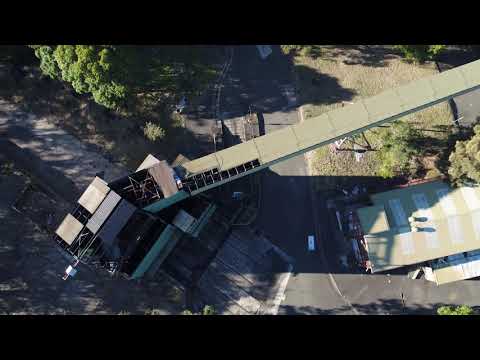 Click here to play video
Drone flyover footage of the existing Coke Works site
Click here to play video
Drone flyover footage of the existing Coke Works site
Documents
-
 1. Draft Planning Proposal May 2021 (Council's Document) (2.77 MB) (pdf)
-
2. Draft Development Control Plan Chapter 19 Former Corrimal Coke Works May 2021 (Council's Document).pdf (3.82 MB) (pdf)
-
3. Draft Planning Agreement Letter of Offer 19 April 2021 (Applicant's Document) (2.44 MB) (PDF)
-
Overview of Key Differences between Proponent's Concept and Council Resolution (Council's Document) (403 KB) (pdf)
-
Master Plan & Visual Impact Analysis (Clousten/DKO E8U/BG&E - June 2021) (Applicant's Document (27.4 MB) (pdf)
-
Landscape Master Plan Report (Clousten Assoc - 17 June 2021) (Applicant's Document) (7.28 MB) (pdf)
-
Corrimal Coke Works Planning Proposal Summary - Traffic Assessment (401 KB) (pdf)
-
Additional Traffic Summary.pdf (463 KB) (pdf)
-
Corrimal Coke Works Planning Proposal Summary - Contamination (305 KB) (pdf)
-
 Council Meetings
-
Council Report 1 November 2021 (34.9 MB) (pdf)
-
Council Minutes 1 November 2021 (211 KB) (pdf)
-
Council Report 19 April 2021 (26.7 MB) (pdf)
-
Council-Minutes 19 April 2021 (459 KB) (pdf)
-
Council Report 26 October 2020 (63.8 MB) (pdf)
-
Council Minutes 26 October 2020 (138 KB) (pdf)
-
Council Report 29 June 2020 (7.56 MB) (pdf)
-
Council Minutes 29 June 2020 (274 KB) (pdf)
-
Council Report and Minutes 3 April 2018 (17.3 MB) (pdf)
-
-
Gateway Determination
-
4. Technical Studies Submitted in Support of Planning Proposal (Applicant) Environment
-
Flora and Fauna Assessment (EcoLogical May 2019) (7.97 MB) (PDF)
-
Letter: Microchiropteran Bat Habitat Assessment (EcoLogical 22 July 2019) (1.46 MB) (PDF)
-
Grey headed Flying fox Camp Proposed Management Actions (EcoLogical March 2020) (5.98 MB) (PDF)
-
Letter: Grey-Headed Flying Fox Camp Management Advice (EcoLogical 16 June 2021) (6.24 MB) (pdf)
-
Letter: Corrimal Flying Fox Strategy Peer Review (Ecosure March 2020) (197 KB) (PDF)
-
Letter: Management and Monitoring of Grey-Headed Flying-Fox (EcoLogical 5 August 2019) (1.54 MB) (pdf)
-
Noise and Vibration Assessment (Renzo Tonin & Associates May 2019) (4.53 MB) (PDF)
-
-
4. Technical Studies Submitted in Support of Planning Proposal (Applicant) Realignment of North Corrimal Creek
-
Creek Realignment Stability Assessment (BG&E 19 March 2019) (12.5 MB) (PDF)
-
Geomorphology Assessment (Soil Conservation Service March 2018) (3.71 MB) (PDF)
-
Corrimal Coke Works Flood Study (Cardno 2 May 2019) (16.7 MB) (PDF)
-
Supplementary Riparian Corridor Information (Clouston Associates 5 August 2019) (2.7 MB) (PDF)
-
Letter: Supplementary Information Regarding Creek Realignment (BG&E 2 August 2019) (526 KB) (PDF)
-
Letter: Riparian Corridor Zoning and Recreation Uses (Clousten 7 August 2020) (245 KB) (pdf)
-
-
4. Technical Studies Submitted in Support of Planning Proposal (Applicant) Contamination & Geotechnical
-
Remediation Action Plan (Arcadis 13 May 2019) (23.1 MB) (PDF)
-
Letter: Interim Advice 3 - Endorsement of Remediation Action Plan (Arcadis 13 May 2019) (Zoic 17 May 2019) (91.1 KB) (PDF)
-
Additional Environmental Assessment (Arcadis 12 April 2017) (89.8 MB) (PDF)
-
Geotechnical Assessment (Douglas Partners May 2017) (2.15 MB) (PDF)
-
-
4. Technical Studies Submitted in Support of Planning Proposal (Applicant) Traffic and Services
-
Traffic & Transport Assessment (Bitzios 23 June 2021) (8.88 MB) (pdf)
-
Letter: Traffic Peer Review (SCT Consulting 21 June 2021) (305 KB) (pdf)
-
Letter: Corrimal Roundabout Access Intersection Proposal (Bitzios 20 May 2019) (1.91 MB) (PDF)
-
Traffic and Transport Assessment (Bitzios April 2019) (17.4 MB) (PDF)
-
Corrimal Traffic and Parking Impact Assessment (McLaren September 2017) (3.21 MB) (PDF)
-
Servicing Strategy Report (Indesco 22 June 2021) (17.6 MB) (pdf)
-
Servicing Strategy Report (BG&E 15 April 2019) (22.5 MB) (pdf)
-
-
4. Technical Studies Submitted in Support of Planning Proposal (Applicant) Heritage
-
Heritage Interpretation Strategy (Urbis June 2021) (52.4 MB) (pdf)
-
Conservation Management Strategy (Urbis June 2021 (59 MB) (pdf)
-
Peer Review: Conservation Management Strategy (Weir Phillips July 2019) (7.38 MB) (pdf)
-
Historical Heritage Assessment (Biosis August 2017) (8.09 MB) (PDF)
-
Heritage Interpretation Strategy (Urbis May 2019) (2.64 MB) (PDF)
-
Conservation Management Strategy (Urbis July 2019) (16.8 MB) (pdf)
-
Structural Assessment of Existing Structures (BG&E 21 June 2019) (7.5 MB) (PDF)
-
Historical Archaeological Test Excavation report (Austral 13 March 2020) (6.74 MB) (PDF)
-
Coke Works Heritage Structures: Image (147 KB) (JPG)
-
Proposed Heritage Strategy: Image (136 KB) (JPG)
-
Indicative Plan Incorporating Proposed Heritage Strategy: Image (148 KB) (JPG)
-
Indicative Elevation Incorporating Proposed Heritage Strategy: Image (109 KB) (JPG)
-
-
4. Technical Studies Submitted in Support of Planning Proposal (Applicant) Economic & Housing
-
4. Technical Studies Submitted in Support of Planning Proposal (Applicant) Review Panel and Consultation
Lifecycle
-
Lodge Planning Proposal with Council
Corrimal Coke Works Development Proposal has finished this stage -
Review by Council and ongoing community and stakeholder engagement
Corrimal Coke Works Development Proposal has finished this stage -
Council decision on merit of the Planning Proposal and seeking Gateway Determination
Corrimal Coke Works Development Proposal has finished this stage -
Gateway Determination by NSW Department of Planning and Environment
Corrimal Coke Works Development Proposal has finished this stage -
Additional Studies and Stakeholder Consultation (undertaken by Proponent)
Corrimal Coke Works Development Proposal has finished this stage -
Public Exhibition Period
Corrimal Coke Works Development Proposal is currently at this stageThe exhibition period will be 60 days and include a Community Information Session in Corrimal.
-
Review submisions and Assessment Report prepared for Council
this is an upcoming stage for Corrimal Coke Works Development Proposal -
Assessment and Determination by Council
this is an upcoming stage for Corrimal Coke Works Development Proposal -
Local Environmental Plan amended if supported by Council
this is an upcoming stage for Corrimal Coke Works Development Proposal
Who's Listening
-
Senior Strategic Project Officer - Planning and Environment
JBPhone 42277111 -
Strategic Project Officer - Planning and Environment
KAPhone 4277111 -
SR